 Michigan House of Representatives of the Michigan Legislature. The current representative is Republican Mark Ouimet.
Area
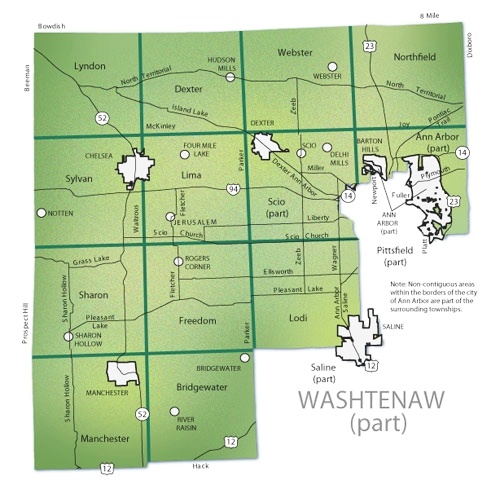
Consists of a majority of western and north-central Washtenaw County, comprising of the far eastern and northeastern parts of the City of Ann Arbor, as well as the cities of Dexter. Chelsea, Manchester and most of Saline; townships represented include Lyndon, Dexter, Webster, Northfield, Sylvan, Lima, part of Scio, part of Ann Arbor, Sharon, Freedom, Lodi, Manchester and Bridgewater. See below for detailed description!
Contact information
Web
In the News
- More Candidates Vie for State House, Senate (Nov 2009)
- Ann Arbor attorney to run for seat in state House (Jan 2010)
- Rundown of the Michigan State House Campagin Filing Statements
- List of 2010 political candidates
District boundaries
You really wanted to know?
Ann Arbor city and Ann Arbor township (part)
That portion of the city which lies north, west of the city limits of Ann Arbor and Washtenaw Ave., west on Washtenaw Ave. to S. Huron Pky., south on S. Huron Pky. to Platt Rd., north on Platt Rd. to Washtenaw Ave., west on Washtenaw Ave. to Sheridan Dr., north on Sheridan Dr. to Overridge Dr., north on Overridge Dr. to Kenilworth Dr., west on Kenilworth Dr. to Sheridan Dr., north on Sheridan Dr. to Londonderry Rd., north on Londonderry Rd. to Glendaloch Rd., east on Glendaloch Rd. to Heatherway St., north on Heatherway St. to Aberdeen Dr., east and then north on Aberdeen Dr., north on Arlington Blvd. to Devonshire Rd., east on Devonshire Rd. to Heatherway St., north on Heatherway St. to Geddes Ave., east on Geddes Ave. to Riverview Dr., north on Riverview Dr. to the township limits of Ann Arbor, west on the township limits of Ann Arbor to Riverview Dr., east on Riverview Dr. to the township limits of Ann Arbor, north on the township limits of Ann Arbor to the Conrail Railroad, north on the Conrail Railroad to the Huron River, north on the Huron River to Fuller St., east on Fuller St. to Bonisteel Blvd., north on Bonisteel Blvd. to Murfin Ave., north on Murfin Ave. to Plymouth Rd., west on Plymouth Rd. to the township limits of Ann Arbor, west, north on the township limits of Ann Arbor crossing railroad tracks and leaving the township limits on Traver Blvd., north on Traver Blvd. to the second crossing of township limits, east, north on township limits of Ann Arbor to Conrail Railroad, north on the Conrail Railroad to Dhu Varren Rd., west on Dhu Varren Rd. to the city/township limits of Ann Arbor, south, west along the city/township limits of Ann Arbor to the southern shore of Barton Pond, west along the southern shore of Barton Pond to the city limits of Ann Arbor, west along the city limits of Ann Arbor to Bird Rd., west on Bird Rd. to Newport Rd., south on Newport Rd. to Newport Creek Dr., west on Newport Creek Dr. to Timber Trail, west on Timber Trail to the city/township limits of Ann Arbor, west, north, east along the city/township limits of Ann Arbor to the point of beginning.
Ann Arbor city Islands
That portion of the city at the intersection of Woodrow St. and Calvin St.
Two Ann Arbor city islands at the intersection of Lakeview Ave. and W. Liberty Rd.
Ann Arbor township Island
Island at the intersection Scio Church Rd. and 1-94. Enclose by Scio township, Lodi township, Pittsfield township, and Ann Arbor city.


