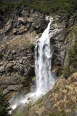
 Photo by carpe_dies on Flickr Feather falls is a 640-foot waterfall located on the Fall River at topographic map coordinates N 39.64309 W 121.27434. It is on Fall Creek, a tributary to the Feather River which feeds into Lake Oroville. Its height makes it the 6th highest waterfall in the United States and the 4th highest in California.
There is a popular day hike to the waterfall from a trailhead about 25 miles east of Oroville. There are two trails that lead to the falls: a shorter, slightly more difficult 3.3 mile trail and the longer 4.5 mile trail that has fewer hills. There are bathrooms at the trailhead, but no running water so be sure to bring plenty with you. Once you've made it to the falls, you can also see a prominent granite dome named Bald Rock.
Here is a Google Road Map with driving directions to the trailhead from Chico.
Above the falls are several swimming holes and camping sites as well; possibly access to a road via the trail there as well.
For more information:


