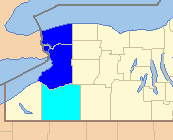
 Cut from WikiMedia The Buffalo-Niagara Falls MSA (Metropolitan Statistical Area) describes a demographic area consisting of the two counties – Erie and Niagara - in Western NY, as shown in dark blue in the map at right. It is the second-largest metropolitan area in the state of New York. The MSA includes the cities of Buffalo, Cheektowaga, Tonawanda, and Niagara Falls.
The MSA also belongs to a larger CSA (Combined Statistical Area) named Buffalo-Niagara-Cattaraugus CSA. The CSA includes the MSA plus Cattaraugus County, shaded in light blue in the map at right.
The CSA (including the MSA) is part of the broader Buffalo-Niagara Region which encompasses eight counties and most of Western NY.
See Wikipedia Article for details.
- Cities
- Towns
- Alden
- Amherst
- Aurora
- Boston
- Brant
- Cambria
- Cheektowaga
- Clarence
- Colden
- Collins
- Concord
- Eden
- Elma
- Evans
- Grand Island
- Hamburg
- Hartland
- Holland
- Lancaster
- Lewiston
- Lockport
- Marilla
- Newfane
- Newstead
- Niagara
- North Collins
- Orchard Park
- Pendleton
- Porter
- Royalton
- Sardinia
- Somerset
- Tonawanda
- Wales
- West Seneca
- Wheatfield
- Wilson
- Villages
- Akron
- Alden
- Angola
- Barker
- Blasdell
- Depew
- East Aurora
- Farnham
- Gowanda (partial)
- Hamburg
- Kenmore
- Lancaster
- Lewiston
- Middleport
- North Collins
- Orchard Park
- Sloan
- Springville
- Williamsville
- Wilson
- Youngstown
- Census-designated places
- Angola on the Lake
- Billington Heights
- Cheektowaga
- Clarence Center
- Eden
- Elma Center
- Gasport
- Harris Hill
- Holland
- Lake Erie Beach
- Newfane
- North Boston
- Olcott
- Ransomville
- Rapids
- South Lockport
- Tonawanda
- Town Line
- West Seneca
- Indian Reservations
- Cattaraugus Reservation
- Tonawanda Reservation (Erie County)
- Tonawanda Reservation (Niagara County)


