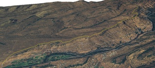
 North Rim Trail (yellow) in "3D", looking generally northwest. Trail data from Open Street Map (thanks to user Beej71 and accomplices!), elevation data from USGS National Elevation Dataset, 2005 color aerial photographs from CASIL. By RyanMikulovsky
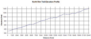
 North Rim Trail Elevation Profile. A long, but gently sloping trail. By RyanMikulovsky The North Rim Trail is one of the longest trails within Upper Bidwell Park, and it affords sweeping views of the park itself. It begins at about an elevation of about 340 feet, making its way east-north-east up to an elevation of 1612ft at a distance of about 4.1 miles, paralleling the edge of the park. The trail ends quite suddenly at a rocky look-out point that's quite worthwhile, but it is not treated nicely by some visitors; watch for broken glass. Since the grade is quite gradual, it's a decent trail to get a good overview of the park or for an easy hike. The trail is well established and much of it is on the hard rock that makes up the Tuscan formation. In the summer, it can be fairly dusty, and mountain bicyclers do enjoy riding it. A few trails connect to North Rim, and they are the Maidu, Blue Oak, B Trail and Live Oak Trail. Live Oak trail and especially the B Trail have steep profiles. B Trail is intended for intermediate to advanced mountain bike enthusiasts.
For easy access to the North Rim Trail, park at lot B or lot E. Lot B has direct access to the trail, while lot E will get you started on an easy climb up Maidu trail, which then intersects North Rim.
 |
This article is in need of a Photo.To add an image to this page, click "Edit" then click the "Files" button. |


