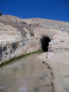
San Vicente Creek is about 9 miles long in Santa Cruz County.

It drains an area of over 14 square miles. It starts near Empire Grade at 2,460 feet and drains into the Pacific Ocean at Davenport Beach. On some maps, this is listed as San Vicente Beach.
History
The San Vicente Creek borders the town of Davenport. The town used San Vicente as one of the names of the settlement. Both the railroad and Highway One travel over San Vicente Creek. A tunnel was blasted and cut from the rocks to all the continued flow of the creek to the sea. The creek was once part of the Rancheo and may have been named for it.
Since 2011, the area above Davenport is named San Vicente Redwoods, for the main creek that flows through it. In Davenport, San Vicente Street goes into the San Vicente Redwoods.
Businesses
The town of Davenport borders San Vicente Creek.
Transportation
Bus service services to Davenport and that area is reachable by Highway One.
Maps
San Vicente Creek is not on some maps. It is not on Yahoo maps, but it is on Google maps.
There is a creek in Southern California with the same name.
 |
This entry is a seed - a starting point for writing a full entry. You can help the Santa Cruz Wiki by expanding it! Simply click on the "Edit" button. |


