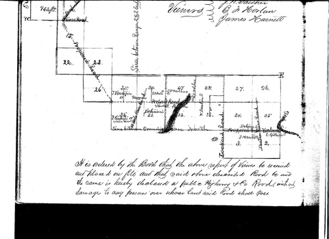
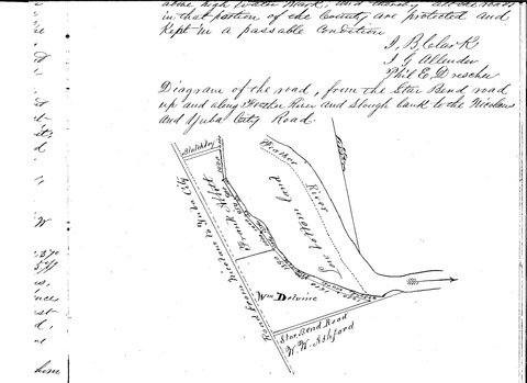
 Star Bend Road runs east and west between the right descending bank of the Feather River and Garden Highway about a mile north of Tudor Road in Tudor and about a mile south of O'Banion Road in Abbott. It provides access to the Feather River and to Department of Fish and Game's Abbott Lake Unit (438 acres) and O'Connor Lakes Unit (471 acres). It is on the opposite side of the river from Star Bend Park and Boat Ramp. For establishment of road, see Sutter County Supervisor's Minutes, Book B, pages 204-206.
Levee District One maintains locked gates on Star Bend Road where it crosses the levee. No one seems to have an idea of why Levee District One gets to do this. Levee District One does not object to pedestrian traffic going around the gates. Levee District One has asked the County to abandon the road, ending the public right of access to the river at this point. The request has been pending since April of 2010. The Fish and Game Units are generally open for public use, although a southern portion of the O'Connor Lakes Unit is closed March through June to accommodate a great egret and great blue heron rookery.
 In looking at the drawing, note that it is "magnetic." That is, you need to twist clockwise about 17 degrees to line it up with a "true-north" image. A related road runs north from Star Bend Road, following the higher ground next to the low bottom lands, either next to or on top of the levee, north to a point across from O'Banion Road, then west to Garden Highway at O'Banion Road. It appears that this road may still represent a public right of way, open for public use.1 For more information, see the California Department of Fish and Game website under "O'Connor Lakes" or RiverPartners.org.
History
There was an Indian village in this vicinity until at least the early 1860s. At that time, the road was part of the Yocolumne-Eddy's Ferry Road.2 The area was within John Sutter's New Helvetia Grant.
A riverboat landing known as "Starr's Landing" was once located on the Sutter County side of the river. It was probably named for George Franklin Starr, a prominent local farmer. Around 1906 the landing was shown as "Ashford's Landing" on some maps, and the road was called "Ashford Lane." W. W. Ashford owned the land at that time. For many years the area was used as a dump.
Comments
2010-06-06 01:58:35 A Google search indicates that the correct current name of the road is "Star Bend Road," not "Starr's Bend Road," and also that "gray egret" is a rarely-used synonym for "great egret." I have edited the page to reflect common usage of those terms. Thanks for the contributions! —queerbychoice
2010-08-22 19:07:51 My greatgrandparents spelled it Starr, USGS shows it as Starr's Landing on the 1888 surveyed Marysville sheet if the Atlas of the United States. The road sign says "Star Bend Road." Now there is "right" and there is "current usage." —75.208.119.158
Footnotes
1. Sutter County Supervisor's Minutes Book b pages 213-225 or so
2. Supervisor's Minutes Book B pages 204-206


